
News
Weather Warming
03/02/2010 06:08Current temps througout the Central US have begun to rise showing a glimpse of spring to come, winter weather has slowly started to fade away but could still make another appearance before spring hits in full force. Temps for the rest of the week througout NE OK are 50's into 60's. Hopefully spring type weather will be here soon so we can update you with some severe weather information! Until then here is a great link from spotterguides.us to help you learn more about severe storms Storm Spotter Guides.
Winter Storm Continues East
01/30/2010 15:15As the winter storm system as moved out the OK area it has left behind a thick layer of ice covered in snow making for dangerous travel on roadways. Tulsa has been reported to have received 6.4" of snow on Friday, while Skiatook and Owasso topped the list for the area with around 7". Gov. Brad Henry requested a federal disaster declaration for all of Oklahoma, where around 164,000 businesses and homes were without power on Friday. The ice on the roadways has begun to melt in areas of high traffic making driving conditions better than they were but still hazardous on many untraveled streets. Overnight temps will drop to the teens which will freeze the roadways again leaving for a dangerous Sunday morning. As the storm has moved east it has continued to drop large amounts of snow, there has been nearly a foot of snow reported for parts of Western NC.
Here is an example of the ice that has been built up on homes in the Tulsa area.

Winter Weather
01/27/2010 00:36 There is a significant winter weather event shaping up for the southern plains that will occur beginning Thursday and go on into the weekend. Large amounts of ice and snow accumulation are expected with this significant weather event. Thursday afternoon upper air charts at 500mb show a system developing in the SWN part of the country. The cold front will swing through and bring energy to the upper atmosphere causing winter weather. Models are showing different variations on how this event will turn out but are mainly agreeing on ice/rain falling then developing into snow later on. 12 Hr accumulated precipitation map for 1-29-10 at 03 UTC shows up to 2" around central OK, totals of 0.5" to 3/4 of an inch of precip. in NE OK with around 1" in Nrn Texas. The following map is a 72 hr. forecast for accumulated snowfall depth for 1-30-10 at 00 UTC.
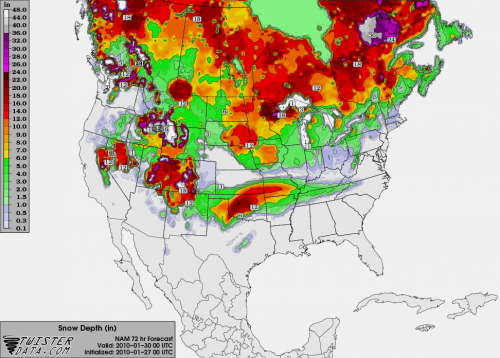
Map obtained from TwisterData.com all rights reserved.
SevereSkies.Net
01/25/2010 01:11Welcome to the new SevereSkies.Net website, we will soon be updating you with severe weather information around the US
SevereSkies.Net launched!
01/24/2010 03:15SevereSkies.Net website has been started today and is being currently worked on, check back soon for updates!

New Outlooks/Team Position Section!
You can look at the current Day 1, 2, and 3 convective outlooks, mesoscale discussions, and view the teams current position in the new Outlooks section so check it out!