
News
5-21 and 5-22 Storms and Tornadoes
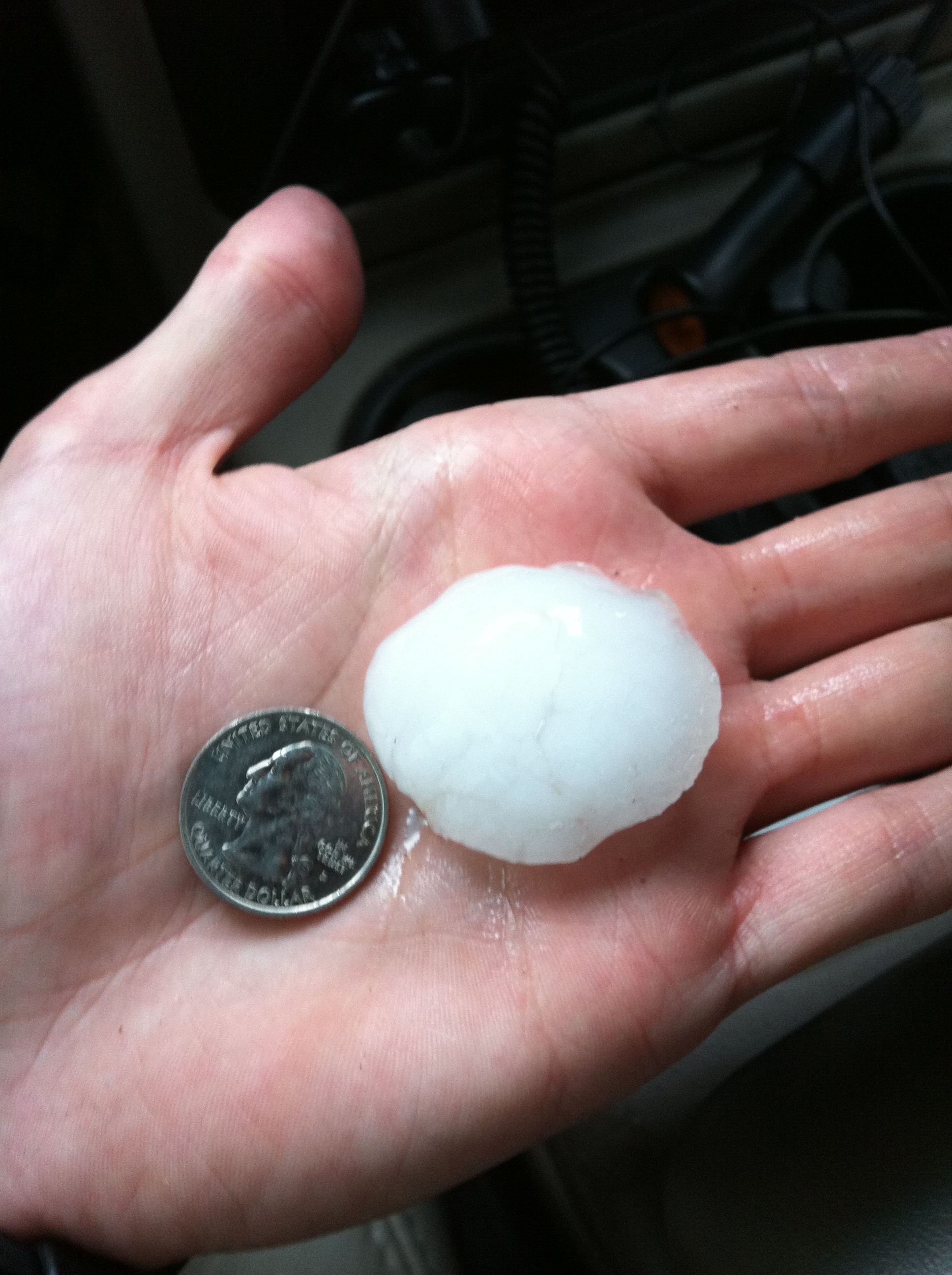
05/22/2011 21:42Multiple tornadoes were observed by the SevereSkies.Net team over the past 2 days near Hickory, Ada, and Mayes County, OK , videos and pictures will be up soon after editing. Here is a picture of hail found between Inola and Wagoner OK, the storm later produced a large tornado
May 14th Lightning <----Click to see full photo
05/14/2010 16:38This shot was taken in Broken Arrow, OK as a storm moved through around 4:30 am by Trechi.

5-10-2010 Noble County Video
05/13/2010 16:46Beneath is video of the Noble County Storm on May 10th. SevereSkies.Net captured a funnel and a brief spinup of a tornado while trying to keep up with the 50-60 mph storm speeds but then got slowed down by some trees in the roadway.
Noble County Tornado
05/11/2010 20:14SevereSkies.Net was able to capture 2 tornadoes and a funnel on video in Noble County OK. As seen in the picture below it is tornado track number 2. The team encountered multiple trees down in the roadway and a powerline down as we tried to catch up to the tornado but eventually lost it due to a unmoveable tree in the roadway and the fast storm movement. Pictures and videos should be up soon so make sure to check back.
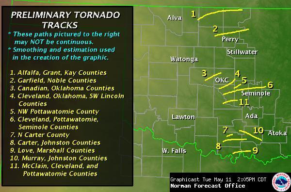
Image is property of National Weather Center Forcast Office in Norman OK.
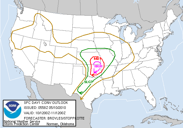
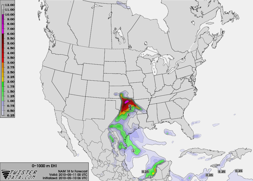
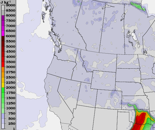
5-10-2010 High Risk Over the Plains
05/10/2010 03:19SPC has issued a High risk over parts of SE Kansas and Eastern Oklahoma with a 30% chance of tornadoes. Models depict a high chance for violent long-track tornadoes over the high risk area late in the afternoon into the evening. 00z NAM (7pm) is showing a large area of CAPE measuring 3000-3500 J KG from S central OK into NE OK mixing with EHI 0-1 KM measuring around 6-7 to the West of the Tulsa area, making a strongly sheared environment being very favorable of supercells and tornadoes. Below are the models described above from TwisterData.Com. The SevereSkies.Net team will be out during this significant and possibly historical weather event, make sure to keep an eye out for severe weather around your areas and begin to prepare.
4-22-10 Jericho TX Tornado
04/24/2010 04:58The following video was taken by SevereSkies.Net on 4-22-10 just south of Jericho TX
Earth Day Action!
04/22/2010 12:19The SevereSkies.Net Chase team is enroute to the Texas panhandle to prepare for severe weather. All the models are showing an area of interest near Childress,Texas which is were the teams target is for now. The cap appears to go away between 2100 and 2200 UTC and with the CAPE and EHI available in the area things should be good.
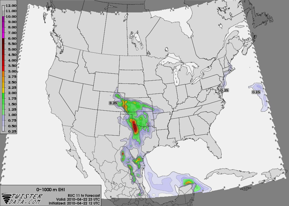
Model obtained from TwisterData.com all rights reserved.
Mesoscale discussion issued for OK
04/06/2010 20:16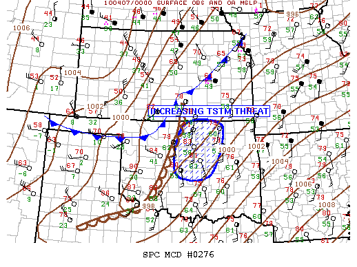
CONCERNING...SEVERE POTENTIAL...WATCH POSSIBLE
VALID 070058Z - 070200Z
COLD FRONT IS SURGING QUICKLY ACROSS NWRN OK AND WILL OVERTAKE NRN
PORTIONS OF THE DRYLINE ACROSS SCNTRL KS/NCNTRL OK IN THE NEXT HOUR.
SUBSEQUENT COLD FRONT/DRYLINE MERGER WILL THEN TAKE PLACE ACROSS
CNTRL OK LATER THIS EVENING. ALTHOUGH SATELLITE IMAGERY DOES NOT
INDICATE ANY MEANINGFUL SUSTAINED CU DEVELOPMENT SOUTH OF KS...00Z
SOUNDING FROM OUN AND LATEST OBJECTIVE ANALYSIS SUGGEST PARCELS ARE
EXPERIENCING LIMITED INHIBITION. ANY INCREASE IN LOW LEVEL
CONVERGENCE OVER THE NEXT FEW HOURS WILL LIKELY RESULT IN
THUNDERSTORM INITIATION...MOST LIKELY EAST OF I-35. WILL CONTINUE
TO MONITOR THIS REGION FOR POSSIBLE WW.
..DARROW.. 04/07/2010
Severe Weather Tomorrow
03/09/2010 22:59The chances for severe weather on Wednesday have increased and current models are depicting areas of concern in the NE Oklahoma, SE Kansas area including parts of Arkansas for tornadoes. The team will be out tomorrow heading for a possible target near Coffeyville KS depending on what the models decide throughout the night. We will make sure to keep you updated throught the event and hope to bring back some good footage.
SPC... AS THE NOSE OF AN 85+ KT MID-LVL JET PUNCHES ENE ALONG THE BASE OF
THE UPR LOW...INCREASING ASCENT AND LOW-LVL CONVERGENCE INVOF THE
TRIPLE POINT WILL YIELD STG/SVR TSTM INITIATION OVER SCNTRL KS OR
NCNTRL OK BY MID-AFTN. ACTIVITY WILL THEN DEVELOP ESE ALONG THE
DRYLINE/OCCLUDED FRONT FROM SERN KS...
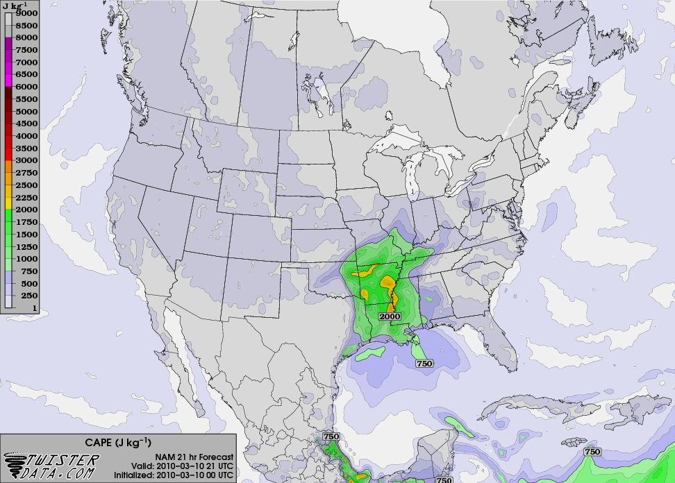
Map obtained from TwisterData.com all rights reserved.
2 Tornados Reported in Oklahoma
03/09/2010 03:26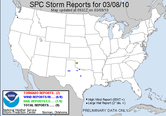
March 8th was the first day of the year for tornadoes in OK as two tornadoes were reported in Wrn OK. One report was in Hammon in the county of Roger Mills and the other was reported 7 mi north of Butler in Custer Co. The SevereSkiesNet team was unfortunately not able to chase today due to our schedule but will hopefully be out during the next severe weather situation.

New Outlooks/Team Position Section!
You can look at the current Day 1, 2, and 3 convective outlooks, mesoscale discussions, and view the teams current position in the new Outlooks section so check it out!